
INTRODUCTION
‘Hydrology’ is derived from two words: ‘hydro’ and ‘logos’. ‘Hydro’ means water, and ‘logos’ means study. Simply, hydrology is defined as the study of water. Hydrology is the science which deals with the origin, distribution and circulation of water in different forms in land phases and the atmosphere.
A broad definition of Hydrology given by US National Research Council
Hydrology is the science that treats the waters of the Earth, their occurrence, circulation and distribution, their chemical and physical properties, and their reaction with the environment, including their relations to living things.
Interdisciplinary subject: As an earth science, hydrology is connected to several subjects.
These include:
– Meteorology: for understanding precipitation and evaporation processes.
– Soil science: for understanding infiltration.
– Geology: for understanding groundwater flow.
– Geomorphology: for understanding surface runoff.
– Hydraulics: for understanding stream flow.
Physics, Chemistry, Biology, Maths, and Statistics: to formulate and understand the subject.
Division of Hydrology
1. Scientific hydrology: deals with hydrological processes from the viewpoint of natural processes.
2. Applied or engineering hydrology: deals with engineering applications of hydrology.
Scope of hydrology
1. Estimation of water resources estimation of water resources.
2. Study of processes like precipitation, evaporation, infiltration and runoff and their interaction.
3. Study of problems like floods and droughts.
Things to be considered for planning and design of water resource projects
a. Maximum flows which are expected to occur at a place.
b. Minimum flows which can occur during any dry period
c. Minimum reservoir capacity to be fixed to meet all water demands from a multipurpose reservoir.
d. Possible regulation of flood at the downstream reaches once a hydraulic structure is erected.
e. Possible supply of water from a river to meet demands for water resources projects.
f. Environmental impacts of a hydraulic structure.
g. Study of groundwater potential and its use.
A watershed is the area of land draining into a stream at a given location. A divide is a line which separates a catchment from its neighbouring catchments. For delineating a basin, we need a topographic map. The map shows changes in elevation by using contour lines.
Features of Contour
– Uphill : Contour with higher elevation
– Hill : Circular contour, ridge at highest point
– Saddle : Mountain Pass
– Valley: U- or V-shaped, with the point of the V/U being the upstream end
– Close together contours: Steep Slope
– Widely spaced contour: level ground
Basin delineation procedure on a topographical map
– Mark the outlet point.
– Mark the highest point around the river.
– Start from he outlet and draw a line perpendicular to the contours in such a way that the line passes from the highest point (ridge)
– Continue to the opposite side of the watercourse, finally ending at the outlet.
Finding the area of the watershed/basin
Method 1: Use a planimeter to measure the area around the boundary.
Method 2: Trace the basin and manually count the area.
Method 3: Use of a GIS package.
Applications of Hydrology in Engineering
– Correct assessment of flows for hydropower, irrigation, drainage and water supply projects.
– Determination of maximum expected flow at dam, reservoir, spillway, bridge, culverts and city drainage system.
– Determination of minimum reservoir capacity sufficient to meet the hydropower, irrigation and water supply demands.
– Estimation of the total volume of water that may be available from a drainage basin over a long period.
– Flood Control: Statistical analysis of probable frequency of floods, estimation of design flood and flood forecasting.
– Computation of water surface profile for various rates of flow for navigation.
– Control of erosion to minimize.
Basically importance of hydrology is categorized in this way.
Design of Hydraulic Structures: Structures such as bridges, causeways, dams, spillways, etc., are in contact with water. Accurate hydrological predictions are necessary for their proper functioning. Due to a storm, the flow below a bridge has to be properly predicted. Improper prediction may cause failure of the structure. Similarly, the spillway in the case of a dam, which is meant for disposing of excess water in a dam, should also be designed properly; otherwise, floodwater may overtop the dam.
Municipal and Industrial Water Supply: Growth of towns and cities, and also industries around them, is often dependent on fresh water availability in their vicinity. Water should be drawn from rivers, streams, ground water. Proper estimation of water resources in a place will help the planning and implementation of facilities for municipal (domestic) and industrial water supply.
Irrigation: Dams are constructed to store water for multiple uses. For estimating maximum storage capacity, seepage, evaporation and other losses should be properly estimated. These can be done with a proper understanding of the hydrology of a given river basin and thus making the irrigation project a successful one. Artificial recharge will also increase groundwater storage. It has been estimated that the groundwater potential of the Gangetic Basin is 40 times greater than its surface flow.
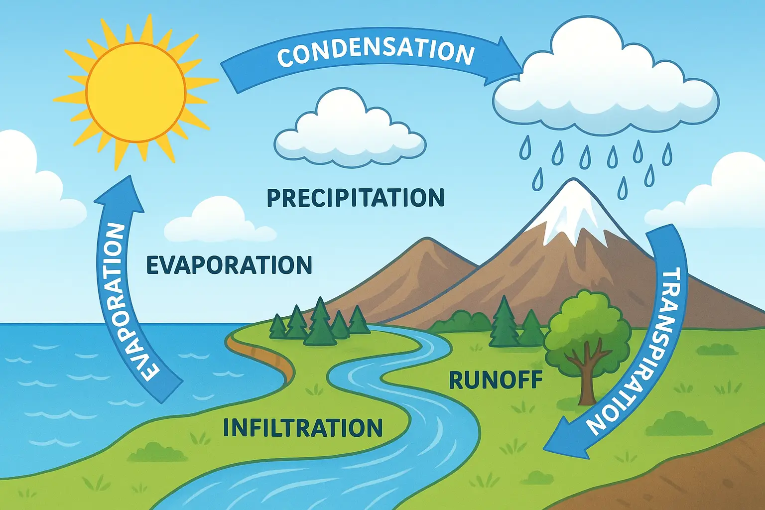
Hydrological Cycle
The endless circulation of water between the earth and its atmosphere is called the hydrological cycle. The hydrological cycle is the most fundamental principle of hydrology. The cycle extends its scope from 15 km up into the atmosphere from the earth’s surface to about 1 km below the earth’s crust through a maze
of paths. It is fueled by solar energy and driven by gravity force.
Processes discussed one by one
a) Evaporation: Water evaporates from the oceans and land surfaces to become part of the atmosphere.
b) Precipitation: Water vapour is transported and lifted in the atmosphere until it condenses and precipitates (falls in the form of solid or liquid) on the land or the oceans.
c) Interception: Part of precipitation is intercepted by vegetation and trees.
d) Infiltration: Part of the precipitation infiltrates into the soil.
e) Surface runoff (Overland flow): The fallen precipitation flows over the land surface before reaching the channel
f) Evaporation and Transpiration: Much of the intercepted water and surface runoff returns to the atmosphere through evaporation. Part of the infiltrated water is available to the roots of the trees and returns to the atmosphere through plant leaves by transpiration.
g) Subsurface runoff (Interflow): The infiltrated water flows laterally through the unsaturated soil to the stream channel.
h) Deep percolation: The water from the soil moisture zone percolates deeper to recharge groundwater.
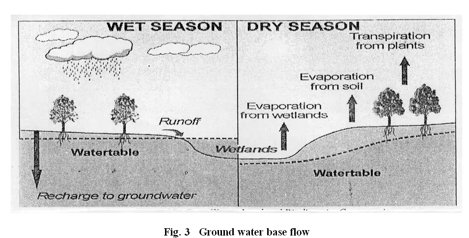
i) Groundwater flow (Base flow): The flow takes place from the saturated groundwater zone to the streams.
j) Final output: Streamflow – The part of precipitation that reaches the stream through different paths above and below the earth’s surface is called runoff. Once it enters the channel, the runoff is called streamflow.
k) Finally, the precipitated water flows out into the sea which it will eventually evaporate once again and the hydrological cycle continues.
Water exists on planet earth in its three forms viz. gaseous, liquid and solid forms and is circulated mainly by Solar and Planetary forces. The Sun provides the energy for the evaporation of sea water and earth’s gravitational field and coriolis force contributes to the circulation of water. The different paths through which the water in nature circulates are the three parts of the total earth system, namely, Atmosphere, Hydrosphere and Lithosphere. The atmosphere is the gaseous envelope above the hydrosphere. Hydrosphere is the bodies of water that cover the surface of the earth. Lithosphere is the solid rock below the hydrosphere. The activities of water extend through these three parts of the earth system from an average depth of about 1 km in the lithosphere to a height of about 15 km in the atmosphere.
Most of the earth’s water sources, such us, rivers, lakes, oceans and underground sources, etc. get their supplies from the rains, while the rain water in itself is the evaporation from these sources. Water is lost to the atmosphere as vapour from the earth, which is then precipitated back in the form of rain, snow, hail, dew, sleet or frost, etc. This evaporation and precipitation continues for ever, and thereby, a balance is maintained between the two. This process is known as Hydrologic Cycle.
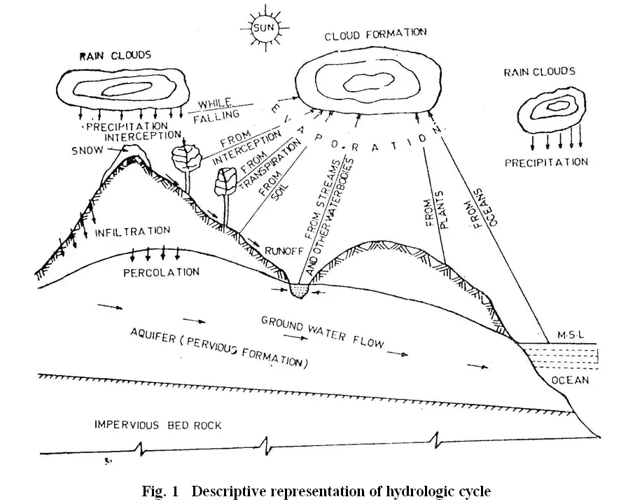
The hydrologic cycle can be represented in many different ways in pictorial or diagrammatic forms. It depends on the view point it represents and is simplified in general as it is difficult to represent all aspects of the cycle. Fig. 1 is a descriptive representation of the hydrologic cycle where many of the details are skipped. Though these figures are self-explanatory, a detailed qualitative description of the hydrologic cycle is given below.
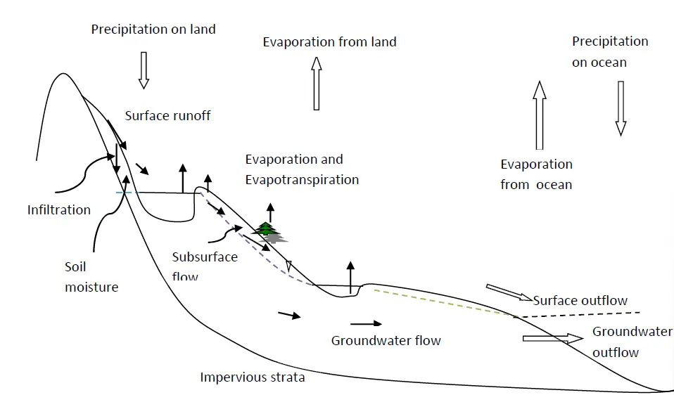
The hydrologic cycle has no beginning or end as the water in nature is continuously kept in cyclic motion. However, for the purpose of description the cycle may be visualised to commence with the precipitation from the atmosphere. Precipitation may take place in liquid form as rain and also in solid form as hail, snow, dew, frost etc. While precipitation is taking place, a part of it may evaporate and reach back the atmosphere. Some more precipitation is intercepted by the trees and vegetation and the rest of it only would reach the ground. The intercepted precipitation eventually evaporates into the atmosphere. The precipitation reaching the ground surface is called the throughfall. Considerable portion of the throughfall gets infiltrated into the ground and that in excess of infiltration would be detained temporarily on the ground before it becomes overland flow and subsequently surface runoff. The precipitation falling directly over the streams is called the channel precipitation and it readily becomes runoff without any delay.
The precipitation falling on the water bodies like ponds and lakes may be disposed of either as surface runoff to streams if the water bodies overflow or as evaporation or as infiltration. The evaporation would also be taking place from stream surfaces.
The infiltrated water may be distributed in different ways. First, it supplies moisture to the vegetation and after utilising it for the sustenance of their life, the vegetation sends this moisture back into the atmosphere through the leaves by a process known as transpiration. Secondly, the infiltrated water may percolate deep and become groundwater supply to surface streams known as the groundwater runoff (Fig. 2 and 3), or it may become groundwater supply to oceans. The groundwater runoff is sometimes referred to as the baseflow or the interflow. The total streamflow which is the sum of the surface runoff and the groundwater runoff ultimately joins the oceans wherefrom it again evaporates into the atmosphere thus completing the hydrologic cycle. The entire cycle repeats when the atmospheric moisture precipitates on to the ground after cloud formation. Thus the hydrologic cycle consists of various complicated processes such as precipitation, interception, evaporation and transpiration, infiltration, percolation, storage and runoff.
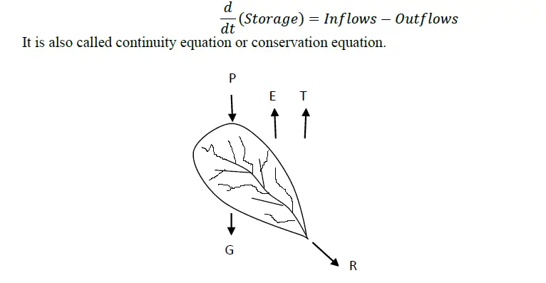
Water budget or water balance equation
The water balance equation is the statement of the law of conservation of mass. Water balance is the balance of input and output of water within a given area taking into account net changes of storage.
Change in storage = Inflows-Outflows
Various Components of Water balance in a basin
General Water budget equation in hydrology of time interval dt,
P-(R+G+E+T)= ds
Where,
P= Precipitation
R= Surface Runoff
G= Net Groundwater flow out of the catchment
E= Evaporation
F= Transpiration
ds=Change in storage (take + for increase in storage, and for decrease in storage)
All the terms in the equation have the dimensions of either volume or depth.
Conversion of unit given basin area: Volume = Depth x basin area
Conversion to volume given flow rate: Volume = flow rate x time duration
In case of other inflows besides precipitation, the water balance equation is :
(P+I)-(R+G+E+T)= ds
Where, I= other inflow
For the long term, e.g. annual water balance, change in storage is zero. The general water balance equation is:
Precipitation-Runoff = Evaporation
Significance of water balance equation
The water balance equation is useful to assess the various components of the hydrological processes for a certain time interval. The input to the system (basin) is precipitation, and the outputs from the system are surface runoff, evaporation, transpiration and groundwater flow. The storage component is the water stored
within the basin. The assessment of runoff using water balance equation is useful for water resources projects, such as irrigation, water supply, flood control, pollution control, etc. The equation is also useful for estimating the change in storage in a reservoir and estimating losses from precipitation.