
Precipitation
Precipitation is any form of solid or liquid water that falls from the atmosphere to the Earth’s surface.
Forms of precipitation :
– Drizzle: water droplets, low intensity, 0.1 – 0.5 mm
– Rain: water droplets, higher intensity, > 0.5 mm
– Glaze: ice coatings formed by freezing rain
– Sleet: ice grains formed due to freezing temperature while falling
– Snow: ice crystals, hexagonal
– Hail: ellipsoid ice balls, 5 to 125 mm
– Dew: during clear nights, when the surface of the object on the earth cools due to radiation, the moisture present in the atmosphere condenses on the surface of these objects, forming water droplets called dew.
Requirements for precipitation formation
- Uplift of air mass into atmosphere
- A gradient in temperature in the atmospheric column – The decrease of air temperature with altitude influences the amount of moisture that can be held as water vapour in the air.
- Water vapour in the atmosphere and saturation as temperature changes in higher parts of the atmosphere (colder), there is less ability to hold water vapour (decrease in pressure).
– Implies that colder air holds less water vapour, leads to saturated conditions (moist air) and promotes condensation. - Presence of nuclei (salt, dust and clay around 1 to 10 μm in diameter, called aerosols) around which condensation of vapour takes place.
- Precipitation product must reach the ground in some form.
Mechanism of precipitation formation
– Water vapour rises in the atmosphere and cools.
– Water droplets in clouds are formed by nucleation of vapour on aerosols.
– Droplets increase in size by condensation.
– Droplets (~0.1 mm) become heavy enough to fall.
– Many of the falling droplets decrease in size by evaporation, which are again carried upwards in the cloud.
– Some of the falling droplets increase in size by impact and aggregation. Some of the larger drops (3-5 mm) may break up into smaller raindrops and droplets. The droplets may again be carried upwards in the cloud.
– When the diameter of droplets becomes 0.1-3 mm, they start falling.
Front terms used for : A front is the interface between two distinct air masses.
Types of precipitation based on lifting mechanism
- Convective
Unequal heating at the surface of the Earth is the main cause of convection. On summer days air in contact with the surface of the earth gets heated up, expands and rises due to its lower density. Surrounding cold air rushes to replace it and, in turn, gets heated up and rises, thus setting up a convective cell. The warm air continues to rise and undergoes condensation. The condensation releases the latent heat of vaporisation, which helps to lift the air mass. Depending on the moisture content, cooling and other factors, the precipitation intensity varies from light showers to cloudbursts. Sometimes, upward wind currents exceeding 150 kmph freeze the raindrops to form hail. - Orographic
Lifting of an air mass over a mountain barrier is called orographic lifting. Dynamic cooling takes place, causing heavy precipitation on the windward side and light on the leeward side. Orographic precipitation gives medium- to high-intensity rainfall and continues for a longer duration. - Cyclonic
A cyclone is a low-pressure region surrounded by a larger high-pressure area. The cyclone centre is called the eye, which is a calm area. This zone is surrounded by a strong wind zone. The pressure decreases towards the eye.
When the low pressure occurs in an area, especially over large water bodies, air from the surroundings rushes in, causing the air in the low-pressure zone to lift. The system derives its energy from sea vapour. Once the cyclone crosses over the land, the energy source is cut off, and it becomes weak and disappears quickly. The rainfall is normally heavy in the entire zone travelled by a cyclone.
An anticyclone is an area of high pressure in which wind tends to blow spirally outward in a clockwise direction in the northern hemisphere and anticlockwise in the southern hemisphere. The weather is usually calm, and such anticyclones are not associated with rain.
Rainfall measurement
Precipitation is measured as the depth of water equivalent from all forms that would accumulate on a horizontal surface if there were no losses.
Unit in MM
Methods of precipitation measurement
a) Rain gauge
b) Radar
c) Satellite
a) Rain Gauge: The type of instrument which is used by hydrologists for the measurement of precipitation (rainfall) or total rainfall is called a rain gauge.
Types of rain gauge
- Non-recording gauge
The gauge, which is read manually, is called a non-recording gauge. It does not record rain itself but simply collects it. It consists of a collector above a funnel leading into a receiving vessel. The rainfall collected in the vessel is measured by a graduated measuring cylinder or dipstick to determine the rainfall depth.
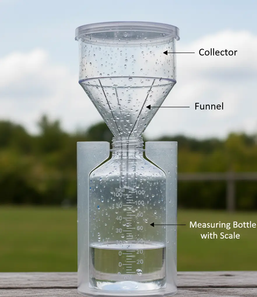
Non-Recording Rain Gauge - Recording gauge
The gauge which records the depth of rainfall automatically is called a recording gauge. Rainfall intensity, duration and depth can easily be obtained from a recording gauge. There are three types of recording gauge in general use.
a) Tipping bucket: A tipping bucket type of rain gauge operates with a pair of buckets. When the rainfall first fills one bucket, it tips and brings the other one into position. The flip-flop motion of the tipping buckets is transmitted to the recording device (clock-driven drum chart) and provides a measure of rainfall intensity. Alternatively, the tipping mechanism is used to actuate an electric circuit which records the number of tips during rain. Usually, one tipping is equal to 0.25 mm of rain. The instrument is suitable for digital data.
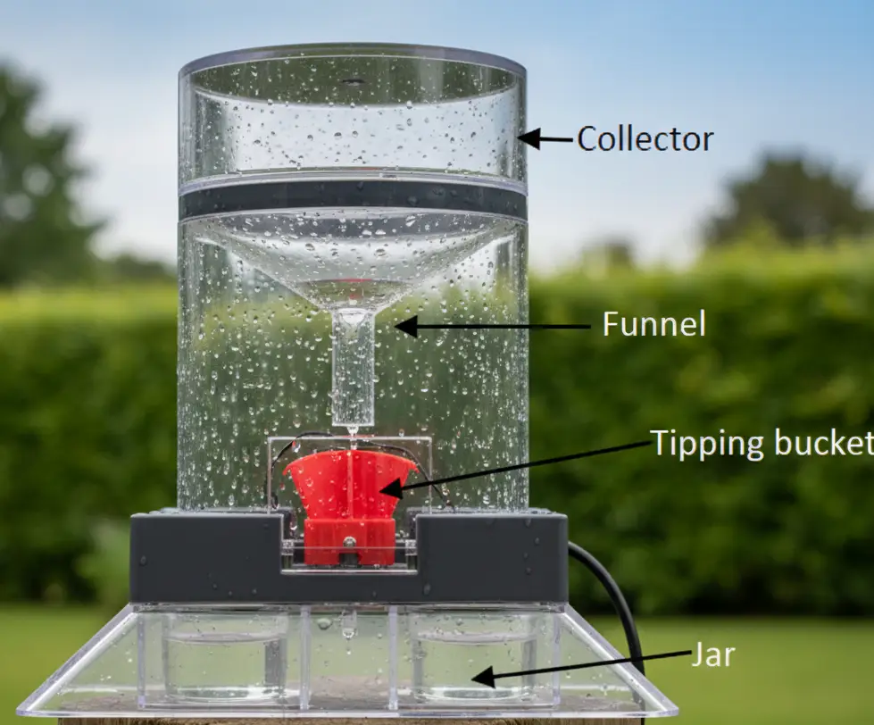
Tipping Bucket Rain Gauge
b) Weighing bucket: In this gauge, rainfall is collected in a bucket which rests on a weighing scale with a spring mechanism. For recording the rainfall, the mechanical lever arm of the balance is connected with a pen which touches a clock-mounted drum with graph paper. The record shows the accumulation of rainfall over time.
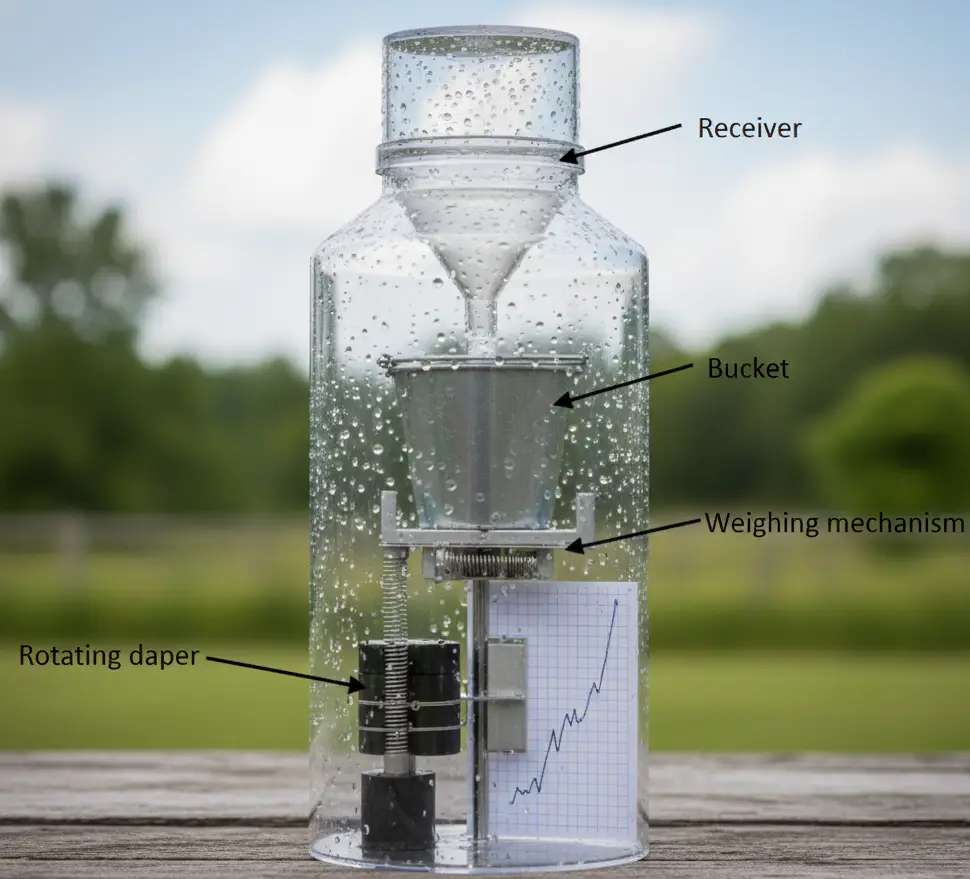
Weighing Bucket Rain Gauge
c) Float type (syphon) gauge: This type of gauge has a chamber containing a float. With the increase in rainwater in the chamber, the float rises. Vertical movement of the float is translated into movement of a pen on a chart, which is mounted on a mechanical clock. A syphon arrangement empties the float chamber when the float has reached the pre-set maximum level. Then the pen comes back to the original zero position, showing a vertical line on the graph. If there is no rainfall, the pen moves horizontally. Each syphonic action measures a certain amount of rainfall, e.g., 10 mm. This instrument provides a mass curve of rainfall.
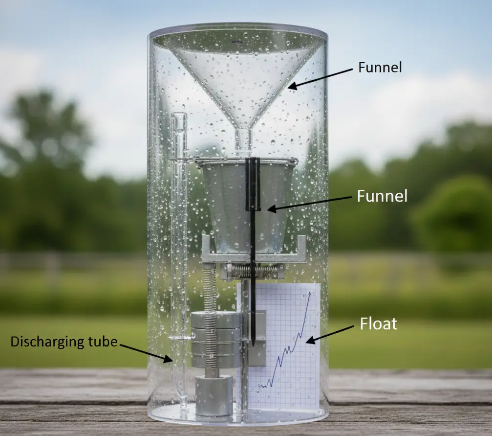
Float type (syphon) gauge
Error in measurement
– Instrumental error
– Human error
– Wind error
– Evaporation Error
– Wetting error
– Splashing Error
Telemetry
Telemetry is a system of transmitting rainfall data to a base station by means of electronic units connected to recording gauges. This system is very useful for mountainous and inaccessible areas. Telemetry is used for real-time transmission of data.
Design of rain gauge network
World Meteorological Organization (WMO) Recommendations (This organization provides office guidelines for National Meteorological and Hydrological Services (NMHSs) and the global weather/climate community.)
| Type of regions | Minimum area for one station under ideal conditions in sq. km. | Area to be covered under difficult conditions per station in sq. km. |
| 1. Flat regions of temperate, Mediterranean and tropical zones | 600-900 | 900-3000 |
| 2. Mountainous regions of temperate, Mediterranean and tropical zones | 100-250 | 250-1000 |
| 3. Small mountainous regions with irregular precipitation | 25 | |
| 4. Arid and polar zones | 1500-10000 |
Optimum number of raingauge stations
Records from all the existing gauges of a basin help to fix the optimum number of stations. The following statistical analysis helps to obtain the optimum number of gauges for a basin on the basis of an assigned percentage of error in estimating the mean areal rainfall.
Where,
N = Optimal number of stations
Ep = Allowable percentage of error in estimating the mean real rainfall
Cv = Coefficient of variation of the rainfall from existing stations.
Method for calculating the coefficient of Variation
Mean of Rainfall:
Standard deviation:
Coefficient of Variation:
Ep is generally taken as 10%.
If Cv is less than 10%, the existing number of stations is assumed to be sufficient. For N>n, the additional station required for the basin are N-n. Annual rainfall data is normally used in this analysis. Basically Normal Rainfall or Avarage rainfall for 30 year period.